ProjectExplorer 5 for Autodesk Civil 3D
User Guide | What's New?
What's New?
In this release, as well as introducing support for Civil 3D 2019, we have implemented some major performance improvements, added multiple selection support, and introduced some new, more consistent, dynamic reporting tools to compare alignment stations/offsets or surface elevations with the locations of other Civil 3D design elements.
New Features
Major Performance Improvements
We have put a great deal of effort into dramatically improving the performance of loading and interacting with complex Civil 3D datasets in the ProjectExplorer user interface. Improvements are particularly noticeable when working with complex pipe networks, alignments, surfaces and point groups.
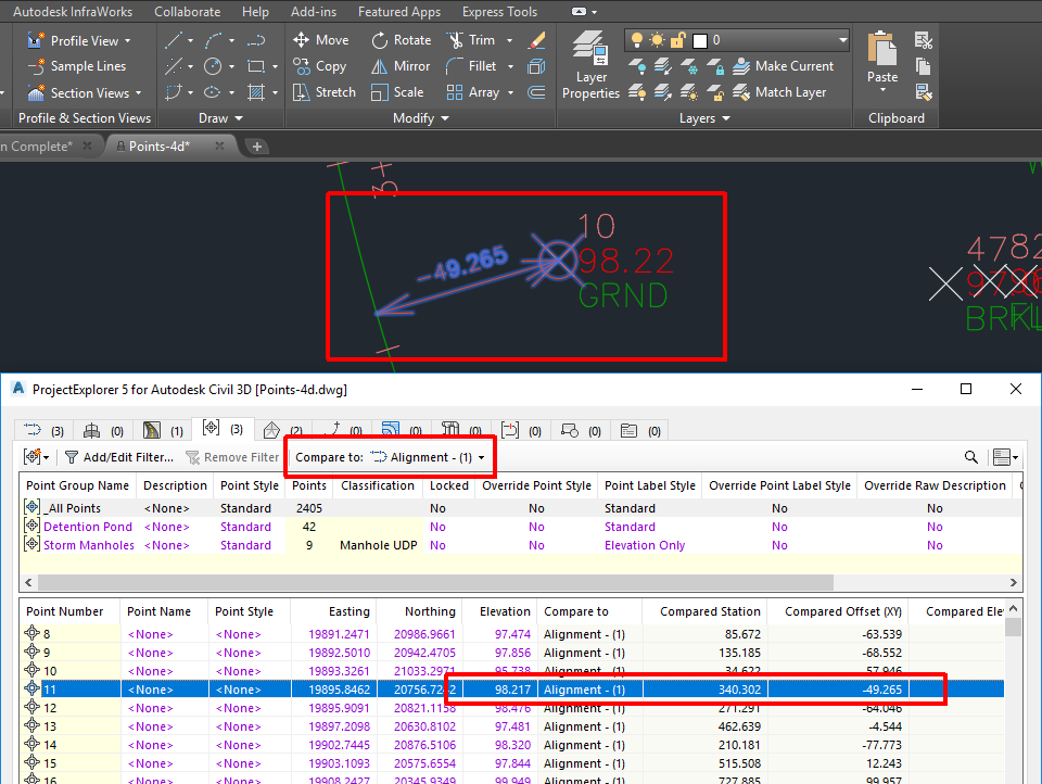
New Alignment Station/Offset Comparison Tools
We have introduced a new set of dynamic reporting tools allowing the location of cogo points, feature line points, parcel segments, and AutoCAD block references to be compared with any Civil 3D alignment or profile in terms of station (chainage), offset and elevation. These tools may be used to generate reports, tables and spreadsheets, or can be used in a live context within the ProjectExplorer window where Civil 3D design changes are reflected dynamically in the results.
New Surface Elevation Comparison Tools
We have introduced a new set of dynamic reporting tools allowing the elevations of profiles, point groups, feature lines, parcels, pipe runs, sample lines, and AutoCAD block references to be compared with the elevation of any Civil 3D surface. These tools may be used to generate reports, tables and spreadsheets, or can be used in a live context within the ProjectExplorer window where Civil 3D design changes are reflected dynamically in the results.
Multiple Selection Support
We have enabled multi-select support throughout the ProjectExplorer user interface. This allows the majority of right-click editing functions to be carried out to multiple objects simultaneously, such as changing object styles, swapping parts, generating quick reports, adding objects to object sets, and much more.
Other New Features
General
- Introduced support for Civil 3D 2019.
- Improved the performance generally of generating AutoCAD tables.
- Introduced more consistent scaling of viewport context highlighting symbols.
- Quick report and object set reporting functions now make full use of any active object comparison selections.
- Description properties (where applicable) are now visible in the ProjectExplorer window for all object types and may be included in outgoing reports and spreadsheets.
- Properties for a range of object types have been re-ordered for better consistency and to accommodate the introduction of Description properties.
- "Start new table after nth data row:" option has been introduced for table styles and report styles. This option is included specifically for reporting surface triangles and cogo points.
- Viewport highlighting for station/offset comparisons now includes text indicating the offset value for the selected point.
- Support has been added for changing Object Names, Descriptions and Object Styles for objects which are derived from data shortcuts.
Alignments and Profiles tab
- New right-click menu items have been added allowing multiple alignment or profile styles to be changed.
- The entity grouping option for alignment/profile points has been removed from the user interface.
- Added a "Compare To" option to compare alignment point locations with other alignments, profiles or surfaces.
- Profile View window now shows a profile line for any active "Compare To" object.
- Point codes and entity type names for alignments and profiles can now be customised.
Assemblies tab
- New right-click menu items have been added allowing multiple Assembly Styles, Assembly Code Set Styles, and Assembly Types to be changed.
Corridors tab
- New right-click menu items have been added allowing multiple Corridor Code Set Styles, Corridor Auto Build Modes, and Corridor Region Lock Modes to be changed.
- Fixed a problem which caused corridor baseline, region and offset baseline properties to be missing from outgoing reports.
- Corridor View "Find" options are now remembered between subsequent ProjectExplorer sessions.
- Solved an issue where region names were missing in corridor baseline point and featureline reports under certain circumstances.
- New right-click menu items and keyboard shortcut support has been added to allow zooming/panning/highlighting for individual corridor lines and points.
- Added a "Compare To" option to compare corridor feature line point elevations with other surfaces.
Point Groups tab
- New Point Group right-click menu items have been added allowing multiple Point Styles and Point Label Styles to be changed.
- New COGO Point right-click menu items have been added allowing multiple Point Styles, Point Label Styles, Raw Description and Description Formats to be changed.
- Removed Point Group paging controls because improved user interface performance means that they are no longer required.
- Added a "Compare To" option to compare cogo point locations with other alignments, profiles or surfaces.
- Improved filtering tools have been implemented for cogo points.
Surfaces tab
- Tweaked the volume surface summary options in report styles to allow them to be shown in report footers even if the report footer fields table is not shown.
- Removed Surface Triangle paging controls because improved user interface performance means that they are no longer required.
- Improved filtering tools have been implemented for surface triangles and cells.
Site Feature Lines Tab
- New right-click menu items have been added allowing multiple Site Feature Line Styles to be changed and multiple Feature Lines to be raised or lowered.
- Changed the "polarity" of grade back values for consistency with Civil 3D Feature Line Elevation Editor.
- Added an Editable (Yes/No) data column for feature lines.
- Fixed a problem with the raise/lower option to ensure it is only available for editable feature lines.
- Added a "Compare To" option to compare feature line point locations with other alignments, profiles or surfaces.
Parcels tab
- New right-click menu items have been added allowing multiple Parcel Styles and Area Selection Label Styles to be changed.
- Fixed a problem with the formatting of the deflection angle property for parcel segments, which was being displayed in radians instead of degrees.
- Added a "Compare To" option to compare parcel segment locations with other alignments, profiles or surfaces.
Pipe Networks Tab
- For pipe networks, new right-click menu items have been added allowing multiple Structure Plan Label Styles, Pipe Plan Label Styles, and Parts Lists to be changed.
- For structures and pipe runs, new right-click menu items have been added allowing multiple Structure Styles and Rule Set Styles to be changed.
- For pipes and pipe runs, new right-click menu items have been added allowing multiple Pipe Styles, Rule Set Styles, and Point Label Styles to be changed.
- Restricted the maximum height of the Start Structure and End Structure dropdown list. Previously these could extend beyond the available height of the AutoCAD window.
- Solved a problem which caused a long delay when opening the Start and End Structure drop down lists for complex pipe networks.
- Added a new property column for Structures showing a list of connected pipe names.
Sample Line Groups tab
- Added property columns for sample line section points allowing the X/Y location of each section point to be reported.
- Added keyboard shortcut support for highlighting the X/Y location of sample line points in the AutoCAD viewport.
- Added a "Compare To" option to compare sample line section point elevations with other surfaces.
AutoCAD Blocks tab
- Added a "Compare To" option to compare block reference locations with other alignments, profiles or surfaces.
Object Sets tab
- Fixed a problem when editing object set properties which occurred if object sets were displayed in a custom order.
- Move to top and move to bottom buttons have been added for changing the order of objects in an Object Set.
Reporting Engine
- Fixed a problem with report header/footer tables where the header column was not being correctly formatted for HTML, DOCX, PDF, RTF, and XLSX files.
- Fixed a problem where an exception could be thrown if an empty Excel worksheet was generated.
- Excel worksheet names for Civil 3D profiles are now derived from the profile name and not the parent alignment name.
Known Issues
- When exporting reports to PDF files, table cell padding values are ignored.
- When exporting reports to PDF files, the "repeat header rows on every page" parameter is ignored.
- When exporting reports to Excel XLSX files, cells containing numerical values are formatted as text.
- When exporting reports to Excel XLSX files, report header images are not supported.
- When exporting reports to Excel XLSX files, column widths are not automatically adjusted to suit column content.
- When exporting to AutoCAD DWG files, complex AutoCAD linetypes (which include shapes or text) are not yet supported.
- ProjectExplorer does not yet support siteless feature lines which were introduced from AutoCAD Civil 3D 2017 onwards. This is due to a lack of API support in Autodesk Civil 3D.
- ProjectExplorer does not yet support Civil 3D Pressure Networks, Catchments or Gradings due to a lack of API support in Autodesk Civil 3D.
- Object Style assignments for Corridors cannot be changed using ProjectExplorer due to a lack of API support in Autodesk Civil 3D.
- In pipe run reports, angle/direction values are not shown the intermediate points of curved pipes.
- For Civil 3D Sample Line Groups, section lines which are sourced from corridors cannot be reported or displayed in ProjectExplorer.
- The ProjectExplorer window doesn't immediately detect certain types of object creation, deletion or renaming when carried out specifically from the Civil 3D Prospector. The suggested workaround is to either manually refresh the ProjectExplorer window after carrying out any impacted operations, or to carry out the impacted operations in the AutoCAD Viewport, Civil 3D ribbon, or ProjectExplorer window.
- When using Formatted Station/Chainage Values (see Layout Options topic), large station values can appear incorrectly formatted in the ProjectExplorer and in reports and tables generated from ProjectExplorer. This is due to a known issue in Civil 3D. The suggested workaround in ProjectExplorer is to use the Raw Station Values option which does not exhibit this issue.
- In Civil 3D 2017, if settings are reset after the installation of AutoCAD 2017 Service Pack 1, ProjectExplorer may not display on the Add In tab, or may not load when the PROJECTEXPLORER command is run. This problem affects all Civil 3D 2017 add-ins and can be solved by installing a hotfix from Autodesk. Click here for further details.
- If the "Delete Points" option in the Civil 3D Prospector window is used to delete all points in a given point group, the deleted points are not immediately removed from ProjectExplorer window. This problem only occurs if the Point Groups tab is open. Suggested workaround is to select another tab in the ProjectExplorer window, then select the Point Groups tab again. This will force an update to the points list in ProjectExplorer.